My friend Ariel invited me to go with him and some of his friends for a two day mtb adventure in the Yungas. Here we are gathering at the stadium in La Paz for the trip over the Cumbre into the Yungas:
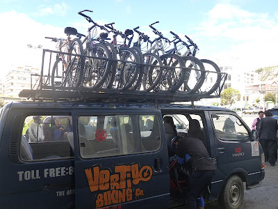
Eventually, the bikes are loaded:
We made a stop for platos pacenos which are corn on the cob, two types of potatoes, fava beans and a couple of thin fried pancakes. Yummy and filling:
We are riding the Eco Via which starts in the same place as the Camino de la Muerte but is much more challenging. The Camino de la Muerte is a road travelled by many motor vehicles daily and, although the consequences of falling off the road would certainly result in death in many places, it is fairly wide and non-technical. It also goes down hill for its entire way.
On the other hand, the Eco Via is impassable by motor vehicle except maybe a light motorcross bike you could carry over landslides and involves about 1,500' of climbing in addition to the 7,000' of descending over it's 30 mile length to Coroico. The Camino de la Muerte has no vegetation covering it and very little standing water. The Eco Via has plenty of both plus many landslides where passage is problematic. Ready for lift off!:
Ariel looks skeptical. The mechanicals are starting already which is inevitable in a group of eight:
The world's most dangerous outhouse:
We had wet conditions but there wasn't too much actual mud:
Nature has her way with the trail:
Looking down on the road to Chulumani, I think. It is now considered by some the world's most dangerous road since the Camino de la Muerte was replaced with the new road:
Never seen one of these before. It's like a cross between a pine tree, a fern and moss:
Another landslide. There were several larger ones further on that I did not photograph because it was raining and I was cold. On the freshest slide, I was a little worried it would go again as I crossed it and sweep me thousands of feet to my demise. But it didn't. This slide was older and seemed stable:
If you enlarge the photo, you can barely see the group climbing to the cumbre of the Eco Via near where I took this shot. I went ahead and missed the mechanicals that slowed the group considerably:
The trail was overgrown in many places but mostly rideable:
Looking back from whence we came:
In the enlarged version, Coroico is visible in the distance. Not far from here, the road split. I waited for the group for a long time but, when I started to get cold again, I followed the road going down because directions painted on a rock indicated that was the way to Coroico. In fact, the better way was straight on the road which was more or less flat to Coroico, although the distance may have been more as it wound around the valley.
I arrived in Yoloso and waited for an hour until it was six o'clock. Yoloso is by the river in the last photo. I slowly realized that the group was not coming and I had better go to Coroico to meet them. I did not know how far uphill Coroico was, or I would have taken a taxi. Fifty two minutes and 1,800' later, we met at the Plaza, more or less at the same time:
After showers, it was time to celebrate at the grill:
The next morning, I am trying to dry my shorts. It would have been better to bring two pair:
Mururata from the other side:
What a great day for the rainy season! I have had such good luck with the weather that I am due to get really hosed sometime:
Like hobbits, we had first and second breakfasts on this morning. Going for first breakfast:
Todo esta seguro. The bikes are resting:
We set out to ride the 7,000' up the Camino de la Muerta but, after three days of riding multiple hours, I was fried. The day was much hotter than when Ariel and I did it a few weeks ago. I thought I would do better on my mtb with the lower gears than the cross bike but, between the heat and fatigue from several hard days, I did two good hours up the road and called it quits. Ariel looks grim but rode well to the top of the dirt and even quite a distance on the pavement. Some of the other guys rode the whole way too which was impressive after a long day on Sunday. I am sorry we did not get a photo of Ariel beside the road in the rain when we picked him up because it was a classic vision of a wasted rider:
This is the best known shot from the Camino de la Muerte but many miles of such drop offs follow below:
Is this thing alive like Hal's Castle?
Looking up towards La Cumbre:
Between the harsh environment of the high country and the lush tropics, life is strange:
Looking down on a small rio that seems perfect for kayaking:
We made a welcome stop in Pongo for trucha. Trucha is trout that tastes somewhat like salmon. Here, the trucha is fresh from the river and is definitely the best that I have had in Bolivia. So good that I had two.
Los chicos had two big days and now they are taking a little rest:
What a great adventure! I can't wait to go back and explore more of the roads and trails of the Yungas.


